Calm Skies but Rough Seas: Why Dangerous Surf Is Hitting California
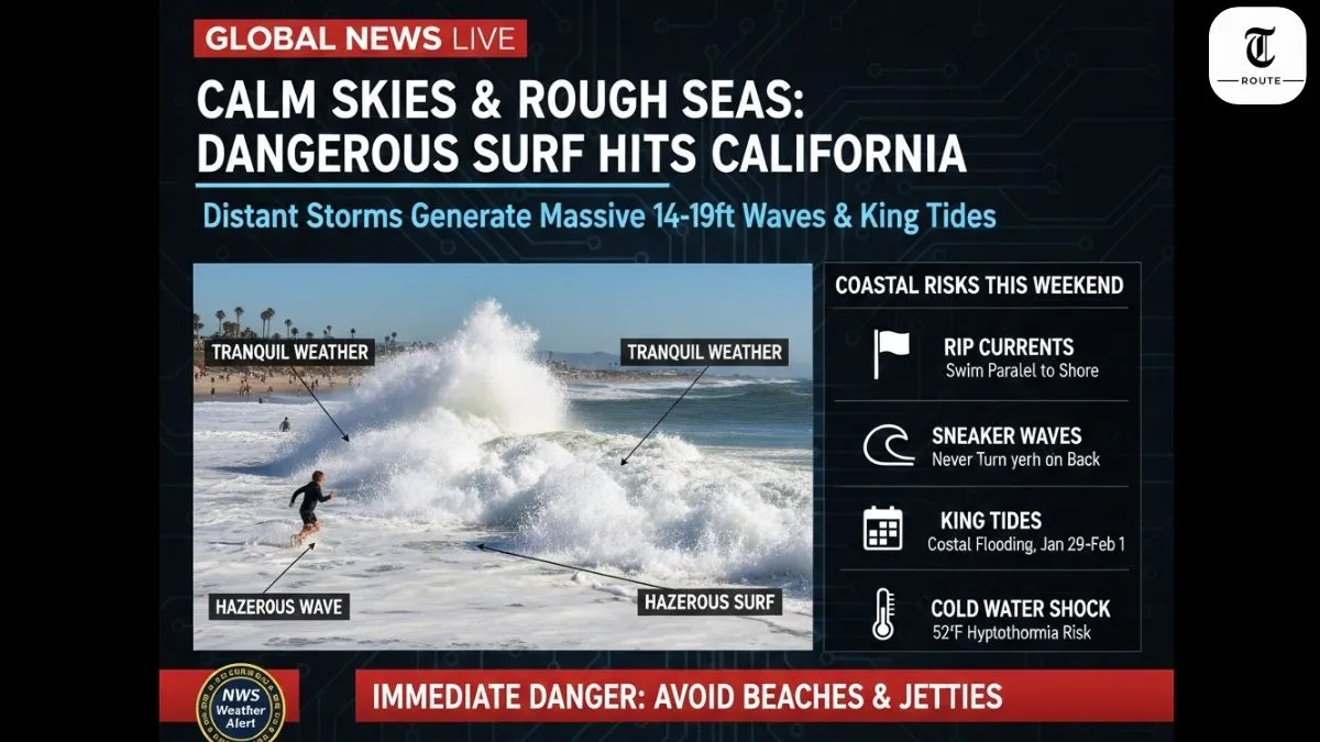
Bay Area enjoys tranquil sunny weather Wednesday while ocean churns violently from distant Pacific storm. National Weather Service issued beach hazards statement: 14-19ft waves through Friday morning. Long-period westerly swell generates powerful rip currents and sneaker waves despite calm onshore conditions. Full moon king tides amplify coastal risks through weekend.
Calm Weather vs Rough Ocean Explained
Swell originates 500+ miles offshore where low pressure storms whip up massive waves. Energy travels as organized swell trains, arriving coherent despite local calm. Long-period swells (15-18 seconds) carry more punch, breaking farther offshore with deceptive power. Bay Area clears Tuesday’s light rain—afternoon highs 60s under clear skies. Ocean doesn’t care about local forecast; distant fetch creates hazardous surf 1-2 days later.
What Are Rip Currents & Sneaker Waves
Rip currents form when waves push water toward shore, narrow channels drain seaward at 5-8mph—faster than Olympic swimmer. Appear calm, darker water; escape parallel to shore, not fighting outbound flow. Sneaker waves strike without warning, running 2-3x normal height during sets. Originate when multiple swell trains synchronize offshore. Recent victims: beachgoers turning back hit suddenly. Never turn your back to ocean.
Coastal Risks This Weekend
Beach hazards statement through Friday 9am: 14-19ft surf, strong rip currents statewide. King tides Friday-Sunday mornings push water 2ft above normal, flooding low-lying areas. Marin County bayside already inundated; SF, Monterey bays expect minor coastal flooding. Highway 1 rockslides possible from wave undercutting. Cold water 52°F hypothermia risk in minutes. Small craft advisory 15ft seas—fishermen stay ashore.
Expert Warnings
Monterey NWS meteorologist Dial Hoang: “Minor coastal flooding starts Wednesday Marin bayside, broader SF/Monterey impacts Friday-Sunday.” Lifeguards report 300+ rescues already this swell cycle. Red Cross: “Most drownings occur in surf <6ft—underestimate power.” Surfline forecasters predict peak destructive waves Thursday AM coinciding with incoming tide. Local authorities closing beaches with high rip risk.
How Long Will Conditions Last?
Beach hazards expire Friday 9am as primary swell fades. Secondary northwest swell pulses Saturday, easing by Sunday. King tides peak Friday 10:26am (2.5ft above normal), Saturday slightly lower. Full moon effects linger through weekend. Next swell train possible early next week—monitor coastal buoys. Climate pattern: La Niña winters deliver bigger west swells to California.
Stay shore-side during peak sets. Float, yell, reach rescues over throw rescues. Know rip escape: swim parallel. Cold water shock kills faster than drowning—life jackets save lives. Check NWS marine forecasts before coastal plans.
Updated January 29, 2026, 9:23 PM IST | NWS Bay Area