If you felt a sudden, sharp bite in the air this week, you aren’t imagining it. As of February 5, 2026, meteorologists have confirmed a complete collapse of the stratospheric Polar Vortex. This high-altitude “spinning top” of cold air, which usually keeps the freeze locked over the North Pole, has officially buckled, sending a massive “tongue” of Arctic air directly into the heart of North America and Europe.
At TruthRoute, we have analyzed the latest high-resolution model data from the ECMWF and GFS to break down exactly what this “collapse” means for your local weather. This isn’t just another cold snap—it is a significant atmospheric event that will redefine the remainder of the 2025-2026 winter season.
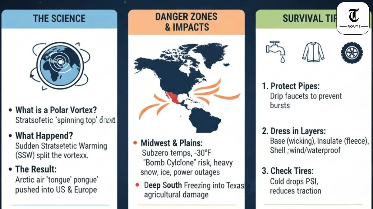
The Science: What is a Polar Vortex “Collapse”?
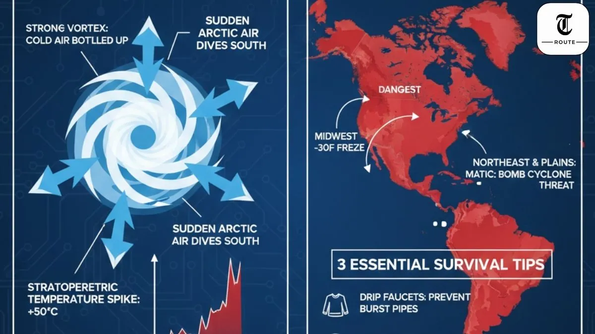
To understand why your heating bill is about to spike, you have to look 30 kilometers above the Earth’s surface. The Polar Vortex is a massive area of low pressure and cold air surrounding the Earth’s poles. When it is strong, it is circular and stable, keeping the cold air “bottled up” in the Arctic.
However, in late January 2026, a Sudden Stratospheric Warming (SSW) event occurred. Stratospheric temperatures over the Arctic spiked by nearly 50°C in just a few days. This heat injected so much energy into the system that the vortex didn’t just weaken—it split into two “daughter” vortices. One of these cores has now drifted over North America, essentially opening the “Arctic Doors” to mid-latitude states.
Which States are in the “Danger Zone”?
The current disruption is not hitting every region equally. Based on the 50mb pressure anomaly charts for mid-February 2026, the cold is being funneled into two primary corridors:
- The Midwest & Northern Plains: States like Minnesota, North Dakota, and Wisconsin are bracing for “painful” subzero temperatures. Nighttime lows could drop as far as -30°F (-34°C), which can cause frostbite on exposed skin in less than 10 minutes.
- The Northeast & Mid-Atlantic: As the cold air meets moisture from the Atlantic, we are tracking a “Bomb Cyclone” risk for New York, Pennsylvania, and New England. This interaction often results in heavy, wet snow and ice accumulation that threatens power lines.
- The Deep South: Unlike normal winter patterns, this collapse is pushing the freezing line deep into Texas and Georgia, raising concerns about agricultural frost and infrastructure strain.
Why This 2026 Event is Different
I’ve tracked several Polar Vortex disruptions over the last decade, but the February 2026 collapse has a unique signature. According to climate scientists at the Woodwell Climate Research Center, the lack of sea ice in the Barents and Kara seas this winter has “stretched” the vortex more than usual.
This “stretched” shape means the cold air isn’t just arriving and leaving; it is becoming blocked by high-pressure ridges over Greenland. This creates a “stalled” weather pattern where the freezing air stays locked in place for 10 to 14 days, rather than passing through in a 48-hour burst.
3 Essential Survival Tips for a Polar Vortex Event
When temperatures drop 30°F below normal, standard winter prep isn’t enough. Follow these expert-level safety steps:
1. Protect Your Infrastructure
The most common damage during a Polar Vortex isn’t from snow—it’s from burst pipes. If your local forecast shows temperatures staying below 20°F for more than 24 hours, keep your faucets at a slow drip. This constant movement prevents ice from forming and building pressure inside the copper or PEX lines.
2. The “Three-Layer” Rule for Clothing
If you must go outside, forget the heavy parka. Use three distinct layers:
- Base Layer: Moisture-wicking material (not cotton) to keep sweat away from your skin.
- Insulating Layer: Fleece or wool to trap body heat.
- Shell Layer: Windproof and waterproof to protect against the “Wind Chill” factor, which can make 0°F feel like -25°F.
3. Check Your Tire Pressure
Physics dictates that for every 10-degree drop in temperature, your tires lose about 1 PSI of pressure. A sudden 40-degree drop can leave you driving on dangerously under-inflated tires, reducing your traction on icy roads.
How Long Will the Cold Last?
The latest ensemble forecasts suggest that the stratospheric wind reversal will persist through at least February 20, 2026. Because the troposphere (where we live) takes time to respond to the stratosphere, we may see the “tail end” of this cold air lingering into early March. If you were hoping for an early Spring, the 2026 Polar Vortex collapse has likely put those plans on ice.
Final Verdict
The 2026 Polar Vortex collapse is a “textbook” example of atmospheric coupling. While it brings beautiful clear skies in some areas, the extreme cold is a genuine threat to life and property. Stay tuned to your local National Weather Service (NWS) office and keep your emergency kits ready. This is the winter of 2026 showing its true strength.
Is the cold hitting your city yet? We want to hear from you. Drop a comment below with your current temperature and any local travel advisories you’ve seen. Your reports help us build a real-time community map of this event.